
Plan Ahead And Prepare – it’s the first Leave No Trace principle listed for a reason. This principle makes all of the other principles easier to follow, with the added benefit of having all the planning taken care of when it’s time to adventure. This makes it sound like I don’t like being flexible at all…I’ll add the caveat, when permits are involved. During the peak season. On a holiday weekend.
Let me step back a smidge; I knew we wanted to adventure for Labor Day weekend, but a brilliant idea didn’t pop into my head until a couple weeks prior. The text to Route went something like this, “WHAT IF we backpack with Soils-4 and Basil to a backcountry climbing spot, then we can go climb for a day while they adventure with Aspen?!” The text to Basil went something like this, “Sooooo I’m thinking backpacking in the Eastern Sierra. Somewhere that has rock climbing and other day adventures. Shall I keep typing?” This was the set up to, it’ll be AMAZING, please hang out with Aspen for a day. Thankfully, it’s quite possible Soils-4 is only friends with me because he loves Aspen, so the dog-sitting was a go!
After looking at the High Sierra Climbing book by Super Topo, we narrowed it down to three options; then realized these options meant nothing without a permit. None were available – blurg… This is where things get complicated. There was plan A, we get a walk-up permit Saturday morning for one of the three spots and hit the trail. Plan B, we get a walk-up permit for Sunday and just do a day climb Saturday. Plan C, stand in the permit line forever because people don’t have any backup plans when they get to the counter and take 30 minutes to get a permit while the line snakes through the entire visitor center!
At this point, I’ll stop complaining and tell you about the amazing adventure that was Labor Day weekend. With permit in-hand for Sunday, Aspen loaded into Soils-4 and Basil’s car to go on a hike while Route and I hit a crag. Coincidentally, we all ended up at the Horseshoe Lake trailhead. Looking ahead of us on the path, “Hey, that’s a cute pup. Hey! That’s our pup!”
Reunited, we all hiked to McLeod Lake, along the north shore then parted ways. The three hikers kept on the main trail seeking views, while Route and I turned along the western shore and headed UP to Mammoth Crest.

Mammoth Crest above McLeod Lake.

Click for larger map.
With Mammoth Area Rock Climbs by Marty Lewis in hand and eyeing the clock after our late start, we set up at the base of Requiem Wall to climb Master Beta, a two star 5.8. Mountain Project didn’t have much beta on Mammoth Crest, but the guide was full of helpful photos and info.

View from the base of Requiem Wall.
Our original goal for the weekend was to try my first multi-pitch, but we were short on time. Instead we treated this single pitch as the start of a multi. Route climbed up the trad route, setting pro along the way, while I belayed from the ground in my climbing shoes. Once he reached the top, he set up his belay for me to climb up to him. At this point my toes were screaming for freedom – not a good sign that I have the right gear for a multi-pitch… I told my toes to harden up and started climbing.

From the top of Master Beta.
This was a bit of a break through climb for me. I had a rack-full of moments when I thought, “How am I going to do this part?!” Then I would do it. All the while in awe of how Route led the tricky sections. I’m such a newb, but I’m getting better pitch-by-pitch and hopefully outside 5.8s won’t seem so hard soon.

Requiem Wall – Master Bata route in blue.
Even though we only got one climb in before we had to meet up at the brewery, we worked through our multi-pitch belay plan and confirmed I needed more comfortable shoes before I could attempt any bigger climbs.

View of the Minarets from Mammoth Crest.
The second portion of plan B was a crowd favorite – backpacking. A quick flashback to Saturday morning; the moment of truth was upon us – we FINALLY made it to the permit counter! Our first choice was full, our second choice was not. No one in our party had been out of Sabrina Basin Trailhead; after we all had a chuckle at Dingleberry Lake, we asked for suggestions on camping. The ranger said it was a popular area and suggested escaping the crowds by heading off trail to Sunset Lake or Moonlight Lake.
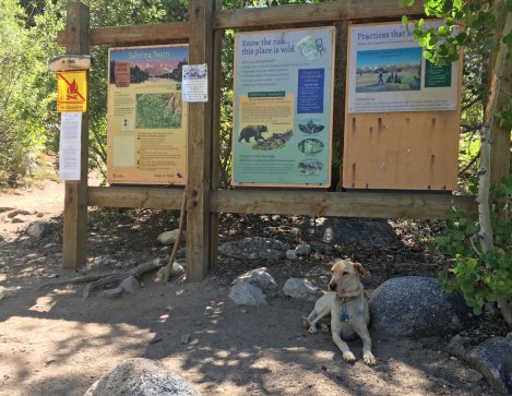
Sabrina Basin Trailhead.
Destination: We found ourselves at Baboon Lakes
Mileage: 10 miles round trip
Trailhead: Sabrina Lake
Elevation: 9,082 up to 10,976 feet
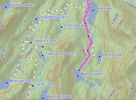
Click for larger map. Also note, I’m in a fight with my GPS software that apparently doesn’t like going off trail – the last stretch is not that straight…
A quick note about the trailhead and parking. The overnight parking is a bit of a walk along the road. We ended up double parking at the actual trailhead, frantically organizing our gear, dumping packs and people, then having the drivers take the cars to the parking area. It was not a relaxing start to the hike and I was amazed by the number of folks in this basin I’d never heard about.

Vista point above Lake Sabrina.
The hike along Lake Sabrina reaffirmed one thing – day hikers LOVE a well accessorized dog. Aspen and her pack were an absolute hit! The hike along the eastern shore was a gradual climb until about two-thirds of the way, then the real climb began switch-backing up the mountain to Blue Lake. Thankfully the crowds thinned out there.
After the trail turns away from Blue Lake, it splits right to Dingleberry Lake and company or left to Donkey and Baboon Lakes. We still hadn’t made an official decision for our destination. I lost at nose goes when the joking turned serious about spinning someone in circles and then having them point a direction. Meanwhile two other groups turned right toward Dingleberry. In an effort to avoid a turtle-on-its-back situation post blindfolded spin, I decided we should head in the opposite direction of the masses.

The trail above Blue Lake.
We still weren’t sure of our final destination so we climbed to Baboon Lakes since Donkey Lake seemed like a bit of a dead end. The trail wasn’t always clear to follow, but with the help of trail markers we made our way up, up, up…until…wow. Just wow. The welcoming view to Baboon Lakes is simply fantastic.

Welcome to Baboon Lakes!
We briefly explored beyond the first lake, but basking on the sun-warmed granite was more enticing. Besides there was no need, we only saw one other tent. How were there no other people here?!

Log jam bridge.
I’ll be honest, hiking around looking for the ideal site had me a bit winded. After looking at the map, it all made sense, we were at nearly 11,000 feet!
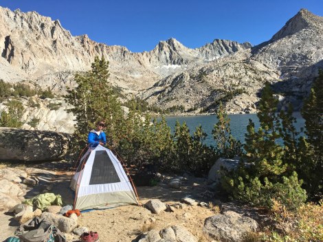
Home for the night.
Baboon Lakes could easily entertain a group for a whole weekend. Exploring up to Sunset Lake, watching for pika, and rumor has it there’s about a zillion fish here.

Morning mirror on the lake.
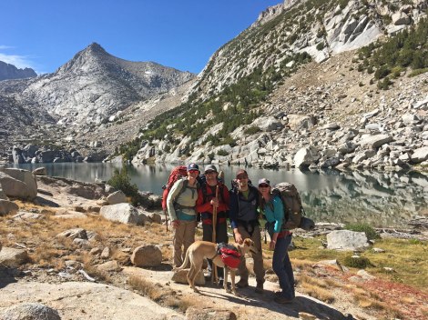
Miss you already!
I would love to spend more time exploring the Sabrina Basin; still not sure how I’ve never heard about this gem in the Eastern Sierra. That would still be the case had we planned ahead and reserved a permit. Interesting… Either way, the ranger’s suggestion was spot on, put a little extra effort in and enjoy the solitude. Also, as soon as you load your pack in the car, head to the nearest brewery!

Post trail brews.
Cheers,
Trails

Wow I just found your blog and think it’s great! As a traveler myself it’s fun to find other blogs and see their amazing pictures! Looking forward to future posts!
Thank you melmcdona! I’ll have to keep an eye on your posts for Utah adventure ideas!
Simply beautiful! I too, just ‘found’ your blog. Love it!
Thanks Mike! It looks like you’ve had some Eastern Sierra adventures too! Sorry your trip to Hoover Wilderness was cut short; but well done making the responsible decision, that’s not always easy.
Pingback: 2016 Blooper Reel | Trails' Guide·