
I had high expectations for this year’s John Muir Trail (JMT) section hike. A handful of folks told me it was the best section of the JMT and raved endlessly about Evolution Basin. And rightfully so – I’m in love with this year’s 80 miles!
Pre-hike: Florence Lake
For the first time on our JMT section hikes we would be starting and ending on the same side of the Sierra crest, which simplified trailhead logistics. Squirrel and I dropped off my car at Road’s End Trailhead and got a ride from my amazing mother and grandparents to Florence Lake. I would like to emphasize how amazing – their little JMT day-long road trip took 17 hours, but saved us the hassle of shuttling cars after we got off the trail and allowed a little wiggle room for our itinerary. Originally we were supposed to finish in seven days, but the high-mileage days and high-elevation passes were a formidable mix and required use of our spare day. Eighty thank yous to those three for shuttling us- one for each mile we hiked this year! They dropped us off as the sun was setting the night before our hike and we dispersed camped north of the general store near the dam in the same spot as last year. Sleeping at 7,590 feet gave us a night of acclimating before our hike began, which is always a plus.
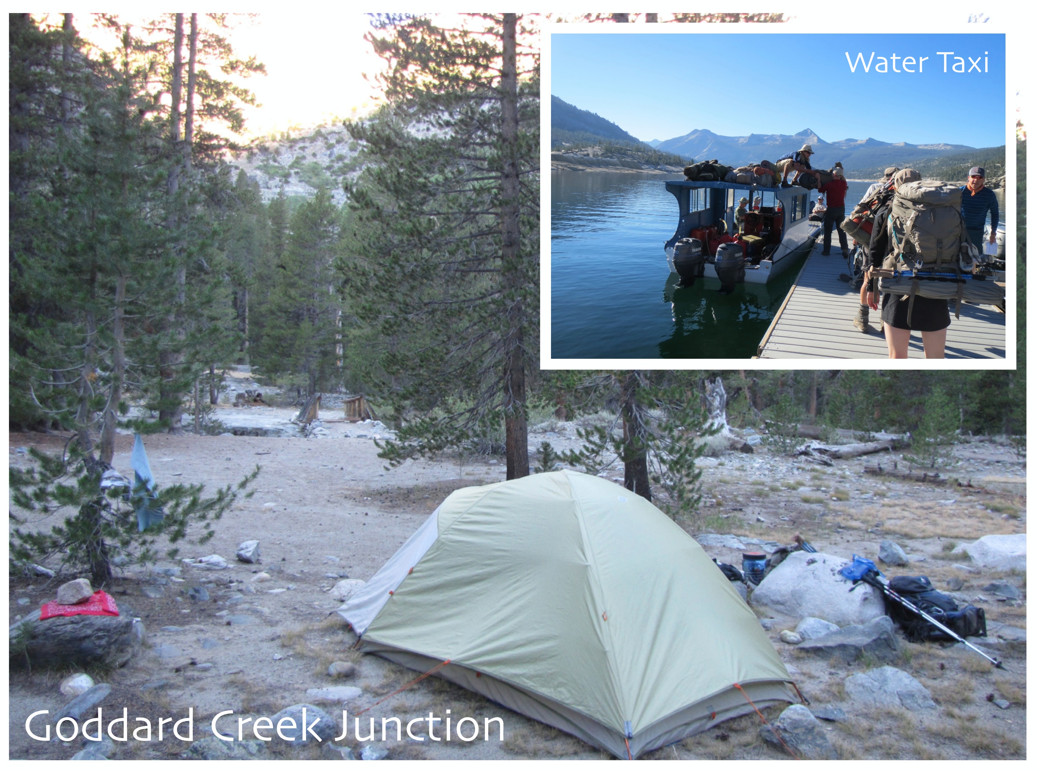
 First Night: Goddard Creek Junction (12 miles)
Squirrel and I were a little worried we’d have to hike the extra 4.5 miles around Florence Lake or take the second water taxi when we crested the hill to the general store at 7:40 a.m. and there was already a group of folks milling about waiting to buy tickets for the 8:30 a.m. run across the lake. Thankfully the large water taxi is more spacious than it appears – the shuttle driver piled packs on the roof and in the center aisle, we all clambered in, and busted out 4.5 miles in 10 minutes. Last year the trail between the dock and Muir Ranch proved to be elusive, but thanks to some trail maintenance and signage we had no problem finding our way back to the JMT. One problem we did have though was a giant rattlesnake on the trail! Through other hikers we learned this stretch of trail is known as rattlesnake alley – good to know!
Once we were back on the JMT it was a hot, but relatively easy, hike to the Goddard Creek Junction where there were lots of camping options. This was a fairly long first day, but the low elevation gain made it doable, plus it put us at the base of the climb up to Evolution Valley.
 Second Night: Evolution Lake (8.2 miles)
We had two climbs on the second day, one first thing in the morning up to Evolution Valley and one at the end of the day up to Evolution Basin. The climb up to the valley was nice and shaded even though we didn’t get on the trail until 9 a.m., I’m pretty sure we didn’t get direct sunlight until we were done switchbacking up the trail. This brought us to our first boot-off river crossing of our JMT experience. Let me just say, after watching Mile…Mile & A Half, I was amazed at the potential torrents that water crossings can be earlier in the season. I’m glad we hike in August; my biggest concern for our crossing was how to attach my camp shoes to my pack to dry after wearing them through the water. Once our feet dried we continued our amble up Evolution Valley to McClure Meadow where we dealt with another trail first – a gear repair. Squirrel discovered a hole in her sleeping pad by laying on the ground half of the night. To find the hole she submerged it in the creek, spotted the stream of bubbles, and applied seam sealer (never backpack without it!) after the sleeping pad dried. We enjoyed the view of Evolution Basin as the sealer dried enough to keep hiking with it strapped under the lid of her pack and would add duct tape later for additional protection. Back on the trail we reached more switchbacks and climbed up, up, up to a rock outcrop across from The Hermit and a grand view back down the valley. After that, the climb became more exposed as it mellowed out. Soon I crested a small hill and felt like we had truly entered Evolution Basin with the craggy mountains laid out before us. We continued up the trail a short ways to Evolution Lake where we found a campsite on a shelf on the northern side and I got a glimpse of my first mountain crush – Mount Huxley.
 Third Night: Little Pete Meadow (12.6 miles)
Our morning hiking up to Muir Pass may be my favorite morning on the trail. We got an early start and as we hiked south folks were descending from their mountain perches to the trail. I don’t know that I can give this image justice in words but it was if all of these people were coming from within the mountains and joining us on the trail – I absolutely loved it! I also loved ogling Mount Huxley all morning as we climbed to Sapphire Lake. I’m pretty sure if mountains could talk he would be saying, “Excuse me, miss my eyes are up here.” After hiking up to the bench that Helen Lake was on I had to say farewell to my mountain crush and hello to the final ascent to Muir Pass and the illustrious Muir Hut. Take the well earned break, enjoy the hut and the view – you’ll need your wits about you going down the south side of Muir Pass. The lose rocks and tricky footing requiring attention to every step leaving us more so mentally exhausted than physically. Have your guard up at the base of the steep decent, for there is a rock monster guarding the trail! Google “JMT rock monster” – you’ll see! With the mood lightened we finished the gradual decent to Little Pete Meadow where we found a group of folks camping that pointed out a nice site above the trail – done.
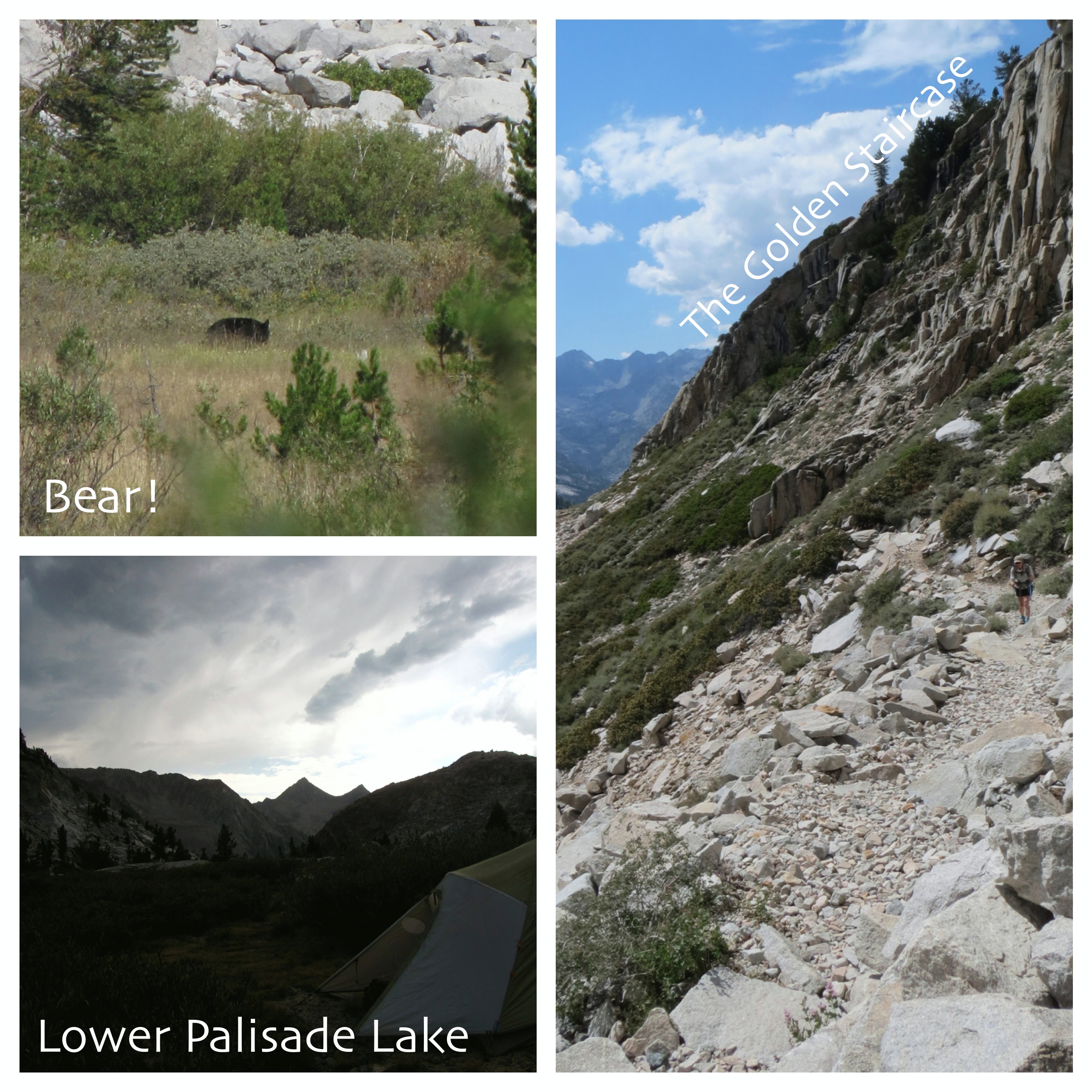
 Fourth Night: Lower Palisade Lake (11.2 miles)
The fourth morning brought yet another JMT first – a bear sighting! Some fellow hikers mentioned they saw a bear and we rushed back to see it. Going in search of a bear doesn’t sound the safest, but the bear was ambling away from us on the other side of a meadow on the other side of a river. With that excitement fueling us, we continued our hike to the daunting Golden Staircase. This section of the JMT was the last constructed and looking up at the seeming granite wall it’s easy to see why. As we climbed switchback after switchback Squirrel eyed the building clouds apprehensively as I enjoyed their shade, but as we crested the climb I agreed – we needed to get to camp! When we arrived at lower Palisade Lake our trail friends had camp set up and filled us in on the camping options, there were lots of sites around the lake’s outlet and granite shelves farther up the trail. We threw our packs down and quickly set up the tent as the clouds took on an Armageddon appearance and the wind coming up the canyon required every warm layer from my pack. Thankfully for us the storm only threatened and dampened hikers elsewhere.
 Fifth Night: Nameless Lake Near Bench Ranger Station (10.5 miles)
I find passes are great places to meet random folks on the trail and hear about their experiences so far. Mather Pass did not disappoint. We met a couple of guys with an abundance of food they inherited from a group that had to abruptly leave the trail due to a rock crushing injury. Giardia, who was hiking the same section we were, joined us at the top for a trail mix break. The Party of Four caught us on the top of the pass and we found out they were also section hiking the JMT. Toward the end of our break we were joined by a young woman I shall call Bliss, because she was blissfully unaware of potential dangers of hiking alone and didn’t understand why her parents worried about her. Don’t get me wrong, I’m all for solo hiking but I had to go to my happy place when she said, “What’s the worse that can happen, a thunder storm?” I wish Bliss had crossed paths with the Food Dudes, so they could have swapped stories…Anyway, Squirrel and I gathered our packs and started down the switchbacks as there were still more miles in front of us than behind us for the day. As we descended we had the pick of premium break locations to filter water and enjoy some Jello instant cheesecake. If you haven’t tried it, I highly recommend it. After our break we continued trudging down to South Fork Kings River crossing and then powered up the climb to the first nameless lake near the Bench Lake Ranger Station. At that point we were pretty done for the day and all I wanted was to jump in a lake. We picked a site, set up camp, and then I went down to the lake. I waded in five feet – water at my ankles. Ten more feet – still ankles. Twenty feet – ankles… I waded halfway across the lake and the deepest it got was my shins. So my jump in the lake turned into laying down in the lake, not exactly what I was after but still nice to get the dirt off. A word of caution – watch your food, this area was teaming with marmots!

Sixth Night: Woods Creek Junction (10.1 miles)
This day marked the last big elevation gain for this section – Pinchot Pass. I promised myself a snack break on the top and powered up to enjoy trail mix with a 360 degree view of stark mountains. It’s funny to think at 12,130 Pinchot Pass was the highest point we’d been on the trail so far and next year we’ll be camping near that elevation – acclimation is the key word here! Steep switchbacks awaited us on the south side of the pass and then lots of sludging down to Woods Creek Junction. Squirrel and I were debating on how to access the JMT for our final year and we weren’t sure if we were going to rehike a few miles or miss a few miles, but I’d read about the suspension bridge over Wood Creek and knew I wanted to check it out in case we miss it next year. Once we got to the junction we were glad to see some of our trail friends at the big camping area with a bear box on the far side of the crossing, so one at a time we braved the suspension bridge and spent our last night on the JMT among friends.
 Seventh Night: Lower Paradise Valley (9.7 miles)
From Woods Creek Junction we headed west toward Paradise Valley and ultimately Road’s End and my car. I had fond memories of Paradise Valley from a hike I did to Mist Falls in 2009, but apparently I have since become a high-elevation snob. After spending time in glorious Evolution Basin, Paradise Valley felt like anything but! There was lots of vegetation scratching my legs, pollen clogging my nose, and seemingly-sweltering temperatures. Maybe I was just bitter to have to leave the JMT behind for another year. At least there was salvation to be found in swimming holes along the trail. Once turning south into Paradise Valley at South Fork Kings River camping was allowed at Upper, Middle, and Lower Paradise Valley, all with a least one bear box. Upper was actually quite nice, but left a few too many miles for the last day, so on we went past Middle to Lower. And we found ourselves back in the pick-up-stick forest with downed trees, marked hazard trees, and one actual branch falling from on high while we were in camp. The marked hazard trees give me hope that they will be felled so at least campers can feel a bit safer soon. One plus was the great swimming hole and beach next to our campsite, I got in for a quick dip so I wouldn’t totally look like Pigpen when we got to the frontcountry.

Eighth Day: Road’s End (5.7 miles)
 Anxious to get on the trail and to my Chacos waiting in the car, we got an early start to our short hike out. Our pleasant morning hike soon turned into a morning run down the trail as a cloud of gnats descended upon us. They were getting caught in my glasses, flying up my nose, buzzing in my ears, daring me to talk so they could check for cavities or whatever the heck they wanted in my mouth for. Once I got my buff in just the right place it solved three of the four problems, but I was still speed-hiking down the trail. As we grew closer to the trailhead we started seeing day-hikers. I was hoping the gnat cloud would attach to them, but after getting whiffs of laundry detergent and soap I understood the gnats much preferred eight-days of trail grime, they were with us ’til the end…This solidified me as a high-elevation snob, leaving me jonesing for next year’s hike up Mount Whitney. Are we there yet?!
Happy,
Trails
John Muir Trail Part One: Devil’s Postpile to Yosemite Valley
John Muir Trail Part Two: Devil’s Postpile to Muir Ranch
John Muir Trail Part Three: Muir Ranch to Woods Creek Junction
John Muir Trail Part Four: Baxter Pass Junction to Whitney Portal

Pingback: 2014 Blooper Reel | Trails' Guide·
Pingback: 2015 Adventure Resolutions | Trails' Guide·
Did you take your dog this entire route? Is it legal?
Hi Jeff,
We hiked the JMT in four sections over four years, the only section Aspen did was the second section. However, dogs can be on the JMT from Yosemite’s boundary in the north to Kings Canyon’s boundary in the south – thank you Forest Service for being dog-friendly! The closest trailhead to Yosemite’s boundary is at Silver Lake on the June Lake Loop then hiking up past Agnew, Gem, and Waugh Lakes. There are various ways to get to the JMT from Silver Lake, but that would put you on the JMT for the most time with your pup. For Kings Canyon you have two options. Florence Lake the the west, which is an easy 5 miles or so – do watch out for rattlesnakes in this area. Or literally at the Kings Canyon border you could head northeast out Piute Canyon to North Lake on the east side of the Sierras, which is 16 miles or so and includes a 11,423 foot pass.
Hope this helps.
Trails
One of my favorite places, the Rae Lakes Loop over Glenn Pass!
That was an absolute gorgeous stretch of the trail!
Great coverage of your trip. Just to clarify, are dogs aloud on the this third section that you hiked? Thank you.
Hi Robert,
Thank you for finding our blog! Aspen did not join us for the third section of the JMT, we were only in dog-friendly country for less than a day before crossing over the National Park boundary. Hope that helps!
Regards,
Trails
I was on this section of JMT in 2014 the 1st week of September with my daughter. We camped at that same lake at the Bench Lake Junction and we were dying to go for a swim. I found a spot knee deep in the middle of the “lake” and rolled around for my swim. I recall a lot of mud too but it was refreshing anyway and got rid of my stink for a little while.
Hi Ape Man,
Thanks for the hilarious flashback – knee deep, what luxury!