
 In keeping with the tradition of part one of our John Muir Journey, we didn’t spend one night where we’d planned. However, I think that was for the best – this itinerary put us at the base of big accents in the morning and under 10,000 feet most nights. Note, we did this section the last week of August which meant easy water crossings, seasonal creeks were dry, hardly any mosquitoes, but also hardly any wildflowers, and ominous looking thunderheads on a few afternoons.
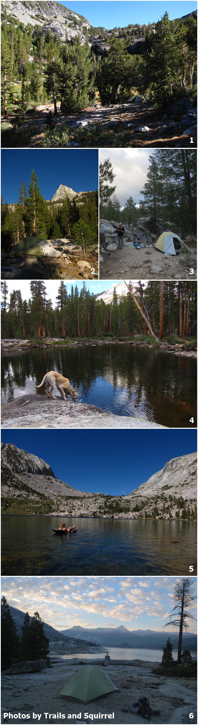
First Night: Devil’s Postpile to Duck Creek (13.2 miles)
Originally our day was supposed to be an easy 6.2 miles to help acclimate to the high elevation. However, we passed our intended destination and arrived at Deer Creek around noon. Not ones to sit around half the day we decided to push on the 5.5 miles to the next water source – Duck Creek (1). Plenty of water and camp was right around 10,000.
Second Night: Cascade Valley Junction (7.4 miles)
I was eying a site at Virginia Lake, but that would have left us with the huge descent to Tully Hole only to head back up in elevation over Silver Pass in the same day. We chose to camp at the Cascade Valley Junction (2) so we could get an early start on the climb over Silver Pass. Fish Creek seemed a bit treacherous to access for water, but there were a few seasonal creeks trickling near the junction.
Third Night: Lake Edison Junction (10 miles)
There were a few campsites north of the bridge over Mono Creek, we picked a site south of the bridge (3) where there were quite a few options. This campsite gave us an early start for the climb up to Bear Ridge – my least favorite part of the trail so far. A grueling accent with many false summits, then when we finally reached the top I asked myself, “this is it?” No view, just more dense trees. The rest of the day’s hike along Bear Creek is full of swimming holes so focus on that.
Fourth Night: Hilgard Fork Junction (8.7 miles)
Legal campsites along Bear Creek are tricky to find – 100 feet from water, 100 feet from the trail. We managed to find one just past the Hilgard Fork Junction across Bear Creek with our own swimming hole (4).
Fifth Night: Sallie Keyes Lakes (6.7 miles)
This was our only other night above 10,000 feet. There were a lot of options for campsites on the knoll between the two larger lakes. There were a couple other parties camping in the area, but we only saw them across the lakes. The water was rather chilly, but doable for a quick swim or float (5).
Sixth Night: Florence Lake (10.2 miles)
We arrived at Muir Ranch mid-day and since it was too hot to get in Blayney Hot Springs we made a run for the Florence Lake water taxi. The trail to Florence Lake is a maze but keep heading west toward the lake and you’ll find the main trail and dirt road. The water taxi driver gave us advice for next year’s start – stay on the dirt road, it may take a little longer but it goes directly to Muir Ranch and you can pick up the well established trail from there.
There’s a little store at Florence Lake with cold drinks, popsicles, and Cheetos – all of which we sampled. There are a few campgrounds in the area and dispersed camping is allowed. We went north of the store and found a sandy bench near the dam overlooking Florence Lake (6).
Completing this stretch marks the halfway point of our journey – can’t wait to get back in the High Sierra next year.
Happy,
Trails
John Muir Trail Part One: Devil’s Postpile to Yosemite Valley
John Muir Trail Part Two: Devil’s Postpile to Muir Ranch
John Muir Trail Part Three: Muir Ranch to Woods Creek Junction
John Muir Trail Part Four: Baxter Pass Junction to Whitney Portal

Pingback: John Muir Trail Part 1: Devil’s Postpile to Yosemite Valley | Trails' Guide·
Are you all floating on a sleeping pad there? & That lake looks beautiful, although looking on the map the trail from Muir Ranch either up or down looks killer! An impressive almost week’s worth of hiking for sure.
That’s my new Nemo sleeping pad/floatation device! It does not self inflate at all, which leaves me a bit out of breath at 10,000 feet, but it packs incredibly small for a full size pad.
And yes, the trail down to Muir Ranch was intense! I think never-ending switchbacks was the theme of this year’s hike – there were four sections of intense switchback elevation change. But don’t let that scare you away, it was a great stretch of the JMT!
hi their. can u answer something for me . from devils post pile ,Is that consisder JMT north trail on permit from Inyo national forest .. I want to make sure when i get mind . And if it is the JMT south is to Florence lake,, thanks you for ur reply.
Hi Joe! Glad to hear you’re exploring the JMT – it won’t disappoint! For your wilderness permit both the JMT north and JMT south are from Devil’s Postpile, it just depends what direction you’re traveling. So if you’re headed south to Florence Lake your starting trailhead would be JMT south. Our exit point was Florence Lake, but there are a few options for exits along the JMT. Let me know if you have any more questions, I’m happy to talk about the trail!
Pingback: John Muir Trail Part 3: Muir Ranch to Woods Creek Junction | Trails' Guide·
Pingback: 2015 Adventure Resolutions | Trails' Guide·
I am using this as a “map” for the exact same route this summer, first time in the US!
Are you doing the full JMT or just a section? Either way – it’ll be amazing, have a fantastic time!